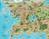


Anyone who use instagram, check Owlcat Games - there was an announcement for announcement of next game which contain some hints. Also, share the picture - apparently we will get more hints more we share the post

Taking a look at it in higher detail, it's clear the pic is broken up into jigsaw pieces.
Assuming this pic is from the new game, I think we can rule out Jade Regent (the towns were smaller, more snowy or less european) and Reign of Winter (the towns were smaller, had an absent landmark in the only area this could be "photographed", more snowy, non-human, or more modern), though neither stood out to me as particularly likely in the first place. Too peaceful for Wrath of the Righteous, though again never a good choice. I'll refamiliarize myself with the big towns visited in Rise of the Ruinlords latter today see it could remotely be them (though it's definitely not Sandpoint). Edit: Likely not Iron Gods either, since the settlements either have gaps between the houses or are polluted messes (and higher tech).
Edit: The settlement doesn't appear to have a wall, at least not in the direct we're seeing. That actually cuts out a lot. So much in-fact I'm doubting it's a representation of any town that exists in an AP and not just random art. That or the art just isn't clear on it having a wall.
edit: It may be Kintargo, the main city of Hell's Rebels. It has one side with no wall, because that side has a river protecting it. That area is also the marketplace and named Redroof because "residences of Redroof possess a distinctive look compared to the rest of Kintargo". All the buildings look like they could have red roofs! The east-facing whole city illustration has Redroof blocked from view, but the outside of the city is compatible. I'm going to guess revealed segments will change the scene from peaceful city to it under martial law.
One of the instagram comments suggest Curse of the Crimson Throne, but I doubt it. Korvosa also has one open side, for the same reason, but that area is the second worst slum in the city and has low building density. The picture clearly isn't that.
This one is easy to figure, you need to look at the jigsaw pieces cut, not at the picture, ignore it, its a part of Golarion world map divided by rivers or roads then rotated . So a second game in the pathfinder universe.
any idea which part of the map? i am trying to puzzle it out by laying a layer of this map with 50% opacity over the picture, but cannot find a match