Galsiah said:
Much of it isn't supposed to be organic.
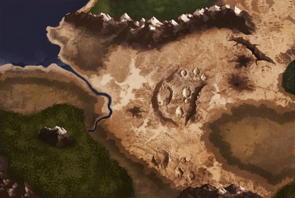
I was unsure about using that word, and i said it. I meant "an existing, alive place that went through a cataclismic ordeal." It looks like no "real" place, but a place existing only to have a cataclismic ordeal pass through it.
Galsiah said:
It's not the result of a natural cataclysm. It's the result of a magical war - targeted, not random or natural.
Yup, i know.
Galsiah said:
Again, it's natural that most of the cratering would focus in particular areas. What exactly do you want in the rest of the map? More craters for no reason? Hills? Is flatland evil? Is a change in detail level necessarily a bad thing anyway? Could a somewhat vague context not be a useful aid to understanding the detailed parts? I'm not sure it particularly matters either way.
Also, consider that most early real-world maps were detailed and (relatively) precise in known areas, and vague and hit-and-miss outside known areas. If the aim is to depict the world as it is known by the inhabitants, then it absolutely should get vague towards the edges. I'm not sure this is the intention, but it'd be a reasonable approach.
That's not what i meant. I actually was refering to the mountains and forest looking out of place, not the "empty" areas. The forest and mountains seem to be just filler, and again that is not conductive to a "real place" feel. Is like a map saying "What for do you want to know what is outside the place the bombs fell? That's side-quest land, at best."
So i said there is a focused area (cataclysm land), and some filler (the rest of the world). A real map is not so, or at least not so blatanty so. It looks like made for a story that focuses on the central crater cluster and the areas immediately (??) west, northeast, and south.
I'd prefer the "unknown" parts, if they are really so, to be left blank, or just sketched but in the same style than the rest of the map. The way it is now is just saying "Nothing to see here." Also, jugding by the river and the mountain, the region is not that big. It is hard for me to believe someone with an interest in those areas couldn't go for a stroll or some trekking and then sell the info to the cartographer. Daring, desperate, and stupid souls are always at hand for humanity to capitalize on. And, if anything, they fill their stories with all bells and whistles they can instead of saying "Big, green forest. Mountain in the middle. Nothing to see here. Gimme my gold."
And my problem with the craters is that they are almost all very well aligned, not that they are too few. The secondary cluster south of the central area is just a joke. Very polite explosions, or whatever they were ._.
Galsiah said:
A river is pretty much a necessity for a coherent settled area. Mountains are a natural border - either you edge the map with mountains (cliché), water (cliché), desert (cliché), or you have it stop for no reason in the middle of nowhere. These clichéd natural borders are a simple way to have a country/empire be reasonably self-contained geographically - making a relatively self-contained history the more reasonable.
These clichés have become clichés because they make sense. Most of the real world looks fairly clichéd too.
I have traveled a bit back in the day, and when i need a map of the area where i am going to no one fill the borders with mountains, deserts, and oceans to make it self-contained. Regions are a part of an ongoing world. They are not self contained. The map ends where it ends because the area they depict ends here. If you are going outside that area, then you buy the next map in line and be done with it.
Point with the river, though. Mea culpa.
Galsiah said:
There you have another point xD