Putting the 'role' back in role-playing games since 2002.
Donate to Codex
Good Old Games
  • Welcome to rpgcodex.net, a site dedicated to discussing computer based role-playing games in a free and open fashion. We're less strict than other forums, but please refer to the rules.

    "This message is awaiting moderator approval": All new users must pass through our moderation queue before they will be able to post normally. Until your account has "passed" your posts will only be visible to yourself (and moderators) until they are approved. Give us a week to get around to approving / deleting / ignoring your mundane opinion on crap before hassling us about it. Once you have passed the moderation period (think of it as a test), you will be able to post normally, just like all the other retards.

In Progress I can show you the world - Let's fly MSFS 2024

Hag

Arbiter
Patron
Joined
Nov 25, 2020
Messages
2,456
Location
Breizh
Codex Year of the Donut Codex+ Now Streaming! Enjoy the Revolution! Another revolution around the sun that is.
unplanned alcohol poisoning
In France we call it Monday.
Indeed. Let's see what the 1990 5th edtion "Manuel du Pilote d'Avion - Vol à vue", official VFR training book endorsed by the Direction Generale de l'Aviation Civile says about alcohol :

"En ce qui concerne la boisson, l'eau est préférable, cependant une petite quantité de bon vin absorbée au cours du repas est sans danger." (p.38)
"Concerning drinks, prefer water, however drinking a small quantity of good wine during the meal is harmless".

Things have probably change since then. And be careful of those weird "vins naturels"

who needs a clock and chronometer
Don’t you guys have phones?

How do you rate your chances to crash before the end, Hag?
A conservative guess would be 99%. I dodged two crashes already, so it's less a question of whether and more of when and where.
 

Hag

Arbiter
Patron
Joined
Nov 25, 2020
Messages
2,456
Location
Breizh
Codex Year of the Donut Codex+ Now Streaming! Enjoy the Revolution! Another revolution around the sun that is.
And welcome for the second part of this trip. Today's word : ridges.

As an introduction, a quick look at the Federation Peak :

federation peak.jpg


And what's become of it in-game :

FP.jpg


Not bad. While the details are missing and the colors are a bit off, the overall landscape shape and lines of sight are spot-on.
Why I am talking about this mountain ? Read on and you'll learn (no, I didn't crashed on it).

Ok, we're set for a 225NM journey.

carte-AA-Tasmanie-LB.jpg


We're doing a silly notch at the beginning to check the Tasman's Ark we've missed last time then some landmarks hopping : the Neck, the Federation Peak, the Port Davey Marine Reserve (yeah, a marine reserve. Sometimes I can't really explain my choices), Gordon Lake Dam, the Gordon river Horseshoe before landing on the small strip of Strahan.

225NM is 418km, not a small walk by any mean and we're going to need a faster aircraft. Enter the Beechcraft Bonanza :

tasbg.jpg


Huge success for this aircraft produced since 1947. It originally had a V tail and uncommon handling characteristics which earned it the nickname "forked-tailed doctor killer". This one is a modern version with conventional tail and glass cockpit, offering the lazy pilot all the modern convenience of autopiloting and moving maps, but somehow still unable to brew him a coffee.

tasbh.jpg


Needless to say, we won't use any of that (even though I could have used a coffee). We're set and ready to go. Notice at the very right of the windshield two kangaroos doing some weird shit.

bugged-a-roos.jpg


Better not disturb them.

Anyway, throttle forward-v1-rotate-positive rate-gear-up-flaps up as would say people paid to fly in real life, and let's take a gander at Hobart, largest city of Tasmania, which is not much to say but still not that backward since, I shit you not, it is the birthplace of Queen Mary of Denmark. Incredible, I know.

Sadly, she's not modeled in-game, but for our viewing pleasure the Tasman's Bridge is here :

tasbi.jpg


You think what I'm thinking ? Yeah, let's crashfly under this shit. Turning and

tasbj.jpg


Wtf
(haven't been able to find any info on that one, but nice catch).
A couple seconds later :

tasbk.jpg


Easy peasy.

tasbl.jpg


The city has full photogrammetric rendering, nice surprise for such a remote place.

tasbm.jpg


Turning East we're coming back to the islands we've left last time. Now let's try to find this goddam ark.


tasbn.jpg


Well, I haven't found anything better than that.
This is what it is suppose to look like :

22-1.jpg


Otherwise, the large creek above the airplane is called the Waterfall Bay, and the deep notch below is the Devil's Kitchen.
Carrying on we reach the small community of Port Arthur, which I wanted to see because of Battletech flashbacks :

tasbo.jpg


Looks quieter. Imagine living in such a remote place. So peaceful. Apart from morons flying down low buzzing them.

tasbp.jpg


Progressing West we see the Neck appearing on the distance. Also to left side is the Southern Ocean. Next stop Antarctica. We won't be going there.

tasbq.jpg


The Neck isthmus. A bit disappointing to be honest. We have the Presqu'île de Quiberon isthmus at home that's way more impressive. Fantastic trivia : the bay down South (at the leftmost part of the screenshot) is called "the Adventure Bay".
Also see that pointy mountain in the distance. That's where we going.
Pushing further we pass Mount Bounty and its comfy-looking pastures :

tasbr.jpg


Nice cliff head at the back.

tasbs.jpg


Notice how luxurious this plane is. It's empty because passengers have terrible uncanny faces in this game. You can have a copilot and sometimes when you turn right he looks straight in your eyes with a Zuckenberg-like void stare. Scary shit.

tasbt.jpg


Reaching the Adamsons Peak, our current target. Next let's find the Federation Peak.

Aaand that's the moment you've been all waiting for : I fucked up.
I had not written down the precise bearing to the peak so I simple eyeballed the highest mountain the broad direction. Turns out it was not the Federation Peak, famous and very photogenic rock-climbing site, but the much more mundane Mount Picton.
The trip was still worth it as the landscape slowly turned dramatic :

tasbu.jpg


tasbv.jpg


Doing a loop around Mount Picton. Not much to say about it.

tasbw.jpg


But some beautiful ridges rich in lakes stretched along and it was very much worth it. I then turned South to get to the Port Davey marine reserve, turns out there was not even a port but only water. That kind of make sense for a marine reserve in retrospect.

tasbx.jpg


Moving North we pass lowlands en route to Lake Gordon, reservoir of the famous Gordon dam. The ridges intensify.

tasby.jpg


Made me wonder what kind of geological phenomenon formed those strange shapes.

tasbz.jpg


And here's the dam, it's 140m high. I don't know what's that vertical thing at its left. Pretty sure it is not a waterfall.

We've seen the Gordon Lake and the Gordon dam, nos let's fly down the - you guessed it - Gordon river :

tasca.jpg


After those austere ridges, we're reaching an easy place of lush and green.

tascb.jpg


Climbing up you can see the lake at the top left. The sea is never too far away.

tascc.jpg


And behold, the Horseshoe bend !
Yeah, great. Maybe there's a reason you had never heard of it before.

tascd.jpg


Flying Westward toward Strahan, over the Macquarie Harbour fjord. It has an average depth of 15m.

tasce.jpg


Strahan, 634 souls, and its airstrip.

tascf.jpg


Buzzing the place. Not much to see.

tascg.jpg


But what an immaculate landing strip !

tasch.jpg


And back to the plancher des vaches, time for cocktails.

But before, debriefing :

carte-AA-Tasmanie-LB-1.jpg


Well, everything went perfectly except that I turned around the wrong summit. I also elected to follow the river downstream instead of jumping some ridge North of the Dam.


And before we part, some Tasmanian tree ferns :

ferns.jpg


See you soon for our last Tasmanian discovery journey before climbing up to the freaking large Australia.
 
Last edited:

Hag

Arbiter
Patron
Joined
Nov 25, 2020
Messages
2,456
Location
Breizh
Codex Year of the Donut Codex+ Now Streaming! Enjoy the Revolution! Another revolution around the sun that is.
It was early morning.

tasci.jpg


Maybe too early actually.

Sky was lighting up in the East, and to the East I was going, to Launceston, where our trip had started :

carte-AA-Tasmanie-LC.jpg


On the distance I could see the mountains, and not much more :

tascj.jpg


It then dawned (eh) on me that the day was not breaking, the clouds were low and it was not going to be fun. So I decided to climb over the clouds to enjoy a spotless view on sunrise. Seeing the Orion constellation on the way :

tasck.jpg


By the earliest light I could see another county airport below :

tascl.jpg


Anytime now :

tascm.jpg


Or so I thought, as the winter/summer Sun is lazy in those latitude.

tascn.jpg


But it was such a show of light. Meanwhile I was climbing to find the Sun fastest, flying orbits over Lake St Clair. And finally :

tasco.jpg


The first rays of the morning. Did I mention this game is gorgeous ?

tascp.jpg


This game is gorgeous.

tascq.jpg


After some more time, I (painfully) reached 20000 ft. Not bad for a plane rated at 13500 ft.

tascs.jpg


Now that light is available, let's get started, one hour into the flight.

tasct.jpg


Those are some low clouds.

tascu.jpg


Low and windy. You can see on the aircraft instrument screen a little arrow next to the compass, with a "22" along. It means there were 22 knots of wind blowing on my tail.

Do you remember, in the movie Airplane, how every time the pilots take their hands of the yoke the plane starts to shake violently ? It was the same here and it was painful to fly. I almost crashed twice because of erratic wind gusts along the mountains that sometimes threw my small plane downward.

tascv.jpg


But the view was worth it.

tascw.jpg


Mount Ossa (1617m).

tascx.jpg


And those lakes. Quite a staple of Western Tasmania. Also the clouds started to clear up.

tascy.jpg


And here is Craddle Mountain. Time head Eastward, crossing broad plateaus :

tascz.jpg


Passing a dam on Lake Cethana, on the river Forth :

tasda.jpg


On of these summit has been cleverly called the "Round Mountain". Guess they ran out of explorer names and Biblical figures.

Meanwhile those ridges and cliffs ease themselves into the fertile plains of North Tasmania :

tasdb.jpg


This fat plateau is Mount Roland, prolonged by a small ridge that forms the Gog Range National Reserve. Its two highest points being called... Gog and Magog.

Now is for long stretches of land, welcome relief after the tiring fights against the mountains winds. But Launceston looks bathed in fog :

tasdc.jpg


Luckily hitting the deck allowed me to fly below it and find my way in the hills out of the town, looking for the next landmark :

tasdd.jpg


The Cataract Gorge, barely a mile away from city center. Btw, see those bridges ?

tasde.jpg


I like bridges.
But it was now time to land in the nearby airport. Just because, I decided to use the VOR radionavigation beacon of the airport to guide me (the green arrow on the compass) :

tasdf.jpg


And we're done !

The flight's trace :

carte-AA-Tasmanie-LC-1.jpg


Actually I was planning to fly a much longer distance and leave Tasmania but I lost so much time at the beginning doing those notches and turns waiting for the Sun to rise I decided to cut it short at Launceston. It was almost a three hours flight already.


Next time we're flying over the NE part of the island, to hopefully island-hop up North and reach the Australian coast !
 
Last edited:

Hag

Arbiter
Patron
Joined
Nov 25, 2020
Messages
2,456
Location
Breizh
Codex Year of the Donut Codex+ Now Streaming! Enjoy the Revolution! Another revolution around the sun that is.
Damn did that look impressive in screenshots, I wonder how it looks in motion.
Well, on the one hand the screenshots are curated and I don't post the more mundane ones, nor the occasional weird texture or building from up close.
On the other hand it looks very good most of the time, the clouds and light effects in particular are top notch and very much the same than in the screenshots, sometimes even better since it's in motion.
Considering how well it runs (I cap at 60fps and read several players saying it was running actually better than the 2020 version) it's a very competent piece of code.
 

Hag

Arbiter
Patron
Joined
Nov 25, 2020
Messages
2,456
Location
Breizh
Codex Year of the Donut Codex+ Now Streaming! Enjoy the Revolution! Another revolution around the sun that is.
Part 4 : Australia ! Horror ! Disappointment ! Promontory !

Now that we've warmed up our wings with this discovery trip of Tasmania, let's get started for real and head North to the huge Australian continent.


Australia-LA-01.jpg


A 410 NM trip. The leg to the East is to see the Bay of Fires and its orange rocks. Then it's a simple matter of island hopping until we catch the Wilsons Promontory Peninsula. I could have landed in Melbourne straight away but I wanted to see the Yarra Valley, famous for its wine (WP12), and most importantly Mount Disappointment (WP13) that, I'm sure, will live up to its name. Then land in Avalon as it's a lovely name.

Such a long trip requires a fast and resourceful steed. And can I find a better choice than the legendary Douglas DC-3 ?

ablaaa.jpg


Arguably the most successful plane ever conceived, with 88 years of continuous service, more rugged and reliable than my old Austrian combat boots, a certain restrained elegance and very fun handling in the game.

ablaab.jpg


And look at that cockpit ! These two large instruments are the interface of the A-3 gyroscopic autopilot, a basic autopilot used in WW2 aircraft. Needless to say, I won't be using it (if only because it's perky and bugged).

ablaac.jpg


We have full comfort for the trip, so let's fire those Wright R-182 Cyclone engines and ride the thin air.

ablaad.jpg


Clear left, clear right.

ablaae.jpg


And here we are again above Launceston's hills, Mount Arthur's shape sitting on the horizon.

mt-horror.jpg


Northern Tasmania is mostly uneventful, safe for the small hill above called Mount Horror ! Behind is Little Mount Horror, which is kind of cute.

ablaaf.jpg


Once again the fertile plains recedes into familiar Tasmanian wilderness.

ablaag.jpg


And once again we find the open ocean. A few thousand kilometers eastward lays New Zealand, but for now let's dive to the Bay of Fires, right in the middle of above screenshot.

ablaah.jpg


Yeah, it's kind of orange I guess. We may need to check closer.

ablaai.jpg


That'll do. Since we talk in the previous posts about how the "real" game looks, I included a few screenshots from lesser favorable angles in this report. So yeah, from close by it can look raw.

ablaaj.jpg


Climbing up we leave the Cape Naturaliste and its lakes. That's the last we'll see of Tasmania. Sayonara.

ablaak.jpg


Very soon we find ourselves over the Lungatalanana Indigenous Reserve Island.

ablaal.jpg


Then Truwana Island.

ablaam.jpg


Then the large Flinders Island.

ablaan.jpg


Passing between Mount Belstead and Mount Razorback in the Strzelecki National Park (this shit is going to turn me into some significant geography buff).

ablaao.jpg


Banking towards the Flinders Island airport, one of my waypoints.

ablaap.jpg


But very soon we're back against the blue sea. Next waypoint is the small Kent Group Islands, the largest being called Dead Island. And finally :

ablaaq.jpg


Australia coast looming shape !

ablaar.jpg


This is the aforementioned Wilsons Promontory peninsula, highest peak Mount Latrobe.

ablaas.jpg


The game UI was so good as to point a landmark there, zooming up we see the silhouette of a lighthouse cleverly named the Wilsons Promontory Lighthouse. Let's close by.

ablaat.jpg


Couldn't manage to snap a better picture.

ablaau.jpg


Let's resume the flight, over the isthmus.

ablaav.jpg


Looks so flat and inhabited compared to savage Tasmania. This sand bank is called Sandy Point. Let's have a moment to think about Western explorers who had to come with a name for anything remotely interesting they stumbled upon.

ablaaw.jpg


Overflying Inverloch, eleventh waypoint. I like this shot.

ablaax.jpg


Quiet plains. The island sitting in the bay on the left is called French Island.
What a nice flight. No turbulence. Easy landmarks. Good plane. Enough fuel. It's so good when all goes according to plan and shit doesn't decide to hit the fan all of a sudden.

Oh, about that :
THEN SHIT DECIDED TO HIT THE FAN ALL OF A SUDDEN.
Engines stopped.
Main tanks were empty.
I switched to auxiliary and restarted the engines.

Nothing happened.

I did it again and still nothing fucking happened and again while checking all the procedures on the internet and still no power and gliding down and again and down and again until FUCK FUCK FUCK SHIT FUCK

oops.jpg


I dedicate this screenshot to Andnjord

I was down, in all but in spirit since I was pissed.
After searching around, turns out the default DC-3 fuel selectors are bugged and can only feed the engines from the main fuel tanks. When they are on the "Off" position. Don't ask me.

Well, I was glad it wasn't my fault, and since it's but a game I managed to respawn, repair and refuel above my crash site and carried on. It was however a tad stressful, almost two hours into the flight, and while I was busy not dying the plane drifted in some random direction, so I was lost. In the end I cheated to identify some nice lake I found on my unplanned path :

ablaay.jpg

That's the Cardinia Reservoir for you, straight East of Melbourne.

ablaaz.jpg


From there it was easy to reach the Maroondah reservoir, waypoint 12, this unassuming lake whose small size and steep surrounding made for a terrible navigation mark. But at last I was above Yarra Valley.

ablaba.jpg


Looks good from above, looks even better on the internet pictures.

And finally :

ablabb.jpg


Mount Disappointment.

No fucking comment.

Let's get over it.

ablabc.jpg


Heading South.

ablabd.jpg


Zooming in the Melbourne direction brings blurry textures and a hand-placed bridge that I may check next time.

ablabe.jpg


Found the airstrip.

ablabf.jpg


There actually was a bit of wind coming sideways, and I was getting tired.

ablabg.jpg


Let's be honest, that was not my best landing.

ablabh.jpg


But this plane can take a beating so it's not grass that'll stop the flight from being successful.
Phew.

Before getting drunkresponsibly prepare next flight, the trace :

Australia-LA-02.jpg


Was good for the most part. The weird loops and westward notch below the Yarra Valley marker are the unfortunate remnants of my crash.
You can notice some unsteady flight and a loop just before landing : I actually tried to home on the airport with the primitive radio-navigation equipment of the DC-3 but a mix of inexperience, tiredness and spacial disorientation made me hunt for the correct heading, and since I arrived to fast I flew a tight loop to bleed off speed.

But at last here we are. We have a continent to cross now.
 

Andnjord

Arcane
Joined
Aug 22, 2012
Messages
3,569
Location
The Eye of Terror
I would say about damn time but the fact that the crash wasn’t your fault is robbing me of any joy.
:rpgcodex:

Either way, t’is a lovely sight for sure. I have to wonder though how many “Sandy Point” there are in the world, it’s not like the explorers had an internet accessible database or even decent maps at the time (those really came in the 19th century).
 

Hag

Arbiter
Patron
Joined
Nov 25, 2020
Messages
2,456
Location
Breizh
Codex Year of the Donut Codex+ Now Streaming! Enjoy the Revolution! Another revolution around the sun that is.
I would say about damn time but the fact that the crash wasn’t your fault is robbing me of any joy.
Don't worry, there's still a long way to go. If anything, crashing so early in the trip promises much more. It is kind of a warm up crash.

Either way, t’is a lovely sight for sure. I have to wonder though how many “Sandy Point” there are in the world, it’s not like the explorers had an internet accessible database or even decent maps at the time (those really came in the 19th century).
Wikipedia lists 20 Sandy Points around the world, half of them in the USA. There are also 27 Rocky Points, 20 Round Mountain, and 1 flat point.
 

Hag

Arbiter
Patron
Joined
Nov 25, 2020
Messages
2,456
Location
Breizh
Codex Year of the Donut Codex+ Now Streaming! Enjoy the Revolution! Another revolution around the sun that is.
Part 5 : Where not much happens

Here is the 439NM trip I planned, kind of counterproductive to head W then E again but there are some mountains range I want to check on the Eastern coast :

Australia-LB-01.jpg


However, soon after takeoff two things became obvious :
- for some reason my joystick-bindings did not work with the P-51 Mustang I was flying, so I had to rebind them all.
- I was quite tired and flying straight was actually difficult.

So I decided to fly halfway to Mount Gambier and its famous Blue Lake (as unique as the thirty-six other lakes named so). I'll start with a small detour to check Melbourne and its bridge we've made out last time.

ablbaa.jpg


The famous Mustang, in all its Flight Simulator glory. Some of you may remember I flew it on some daring DCS trip, so I was eager to compare the two version. Alas, here it is very rough if not bugged. Its engine is overpowered and keeps the same speed whatever you do, it is a bitch to take-off and land because of its ridiculous torque, almost no engine systems are modeled, its range is ridiculously short (while the real-life plane was known for its long endurance) and its default liveries are ugly. Somehow the two-stages supercharger does work.
But it was disappointing, and while its speed could have made it the perfect vehicle for the long legs above the infinite landmass that awaits us soon I'll think twice now before choosing it.

ablbab.jpg


Still it did its job.

ablbac.jpg


Brought us to Melbourne downtown.

ablbad.jpg


The bridge !

ablbae.jpg


Business as usual.

ablbaf.jpg


The photogrammetry can be weird from up-close.

ablbag.jpg


The city looks a bit scorched to be honest, I hope it is more pleasant to live than it looked from this brief virtual overflight.

ablbah.jpg


You can guess some landmass in the distance, Maybe King Island, a large empty land NW of Tasmania (one of 15 of the same name).

ablbai.jpg


Some funky lagoons.

ablbaj.jpg


Pushing West, the forests of the Great Otway.

ablbak.jpg


Arriving at Lorne. There is some well-known waterfall called the Erskine Falls close by, it was actually a waypoint but there was nothing in-game.

ablbal.jpg


Cute hills above Apollo Bay.

ablbam.jpg


Nice... waves ? cliffs ? glitches ?

ablban.jpg


Land of small hills ceding to flatter, more arid farmlands.
But also home to the Twelve Apostles !

ablbao.jpg


Or so is the prestigious name of those solitary rocks dropped along the coast, one of the most famous tourist attraction of the state (and modeled in game with a higher resolution). Closer you can see a deeper bay along the cliffs, it is the Loch Ard Gorge, famous place of an eponymous shipwreck. Also the uncommon rufous bristlebird (Dasyornis broadbenti) is often observed around the Gorge.

ablbap.jpg


Carrying on. This surprisingly festive estuary is home of the Peterborough Coastal Reserve. Nearby, by the coast and probably out of the screenshot is the Massacre Hill.

ablbaq.jpg


The dry coast of Port Fairy. Far in the distance appears the green summits of the Grampians National Park, home of such marvels are Mount Abrupt and Mount Marum Marum, and that we will cross next time.

ablbar.jpg


And here we arrive at Mount Gambier with not one, but two lakes awaiting us. Closer is Valley Lake, above is the Blue Lake, quite deserving of its name indeed (the color is true to life), and is also called Warwar. It is a crater lake.

ablbas.jpg


And close North is the Mount Gambier airport, where I wrestle the far too nervous aircraft to a decent landing.

ablbat.jpg


Could be worse.

So in the end :

Australia-LB-02.jpg


Worst navigation so far, since I was a bit too tired for this shit and mixed two peninsulas during the long leg over water.
Onto next time, have a fresh one, and if you fly do it cautiously.
 

Andnjord

Arcane
Joined
Aug 22, 2012
Messages
3,569
Location
The Eye of Terror
“Massacre Hill”

I use to live in a place, it was called Kilburn, street name Shoot Up Hill. Sometimes people get tired of the Avenue Roads or Sandy Points and get a little bit more grim.
 

Hag

Arbiter
Patron
Joined
Nov 25, 2020
Messages
2,456
Location
Breizh
Codex Year of the Donut Codex+ Now Streaming! Enjoy the Revolution! Another revolution around the sun that is.
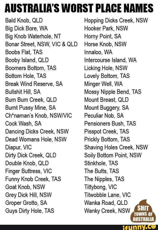
Good news everyone ! I light of those recent discoveries I am glad to announce our trip will take us to Mount Buggery and Bullshit Hill !
 

As an Amazon Associate, rpgcodex.net earns from qualifying purchases.
Back
Top Bottom