Hello everyone, and welcome to the second development diary for Imperator! This time we’ll talk about our map!
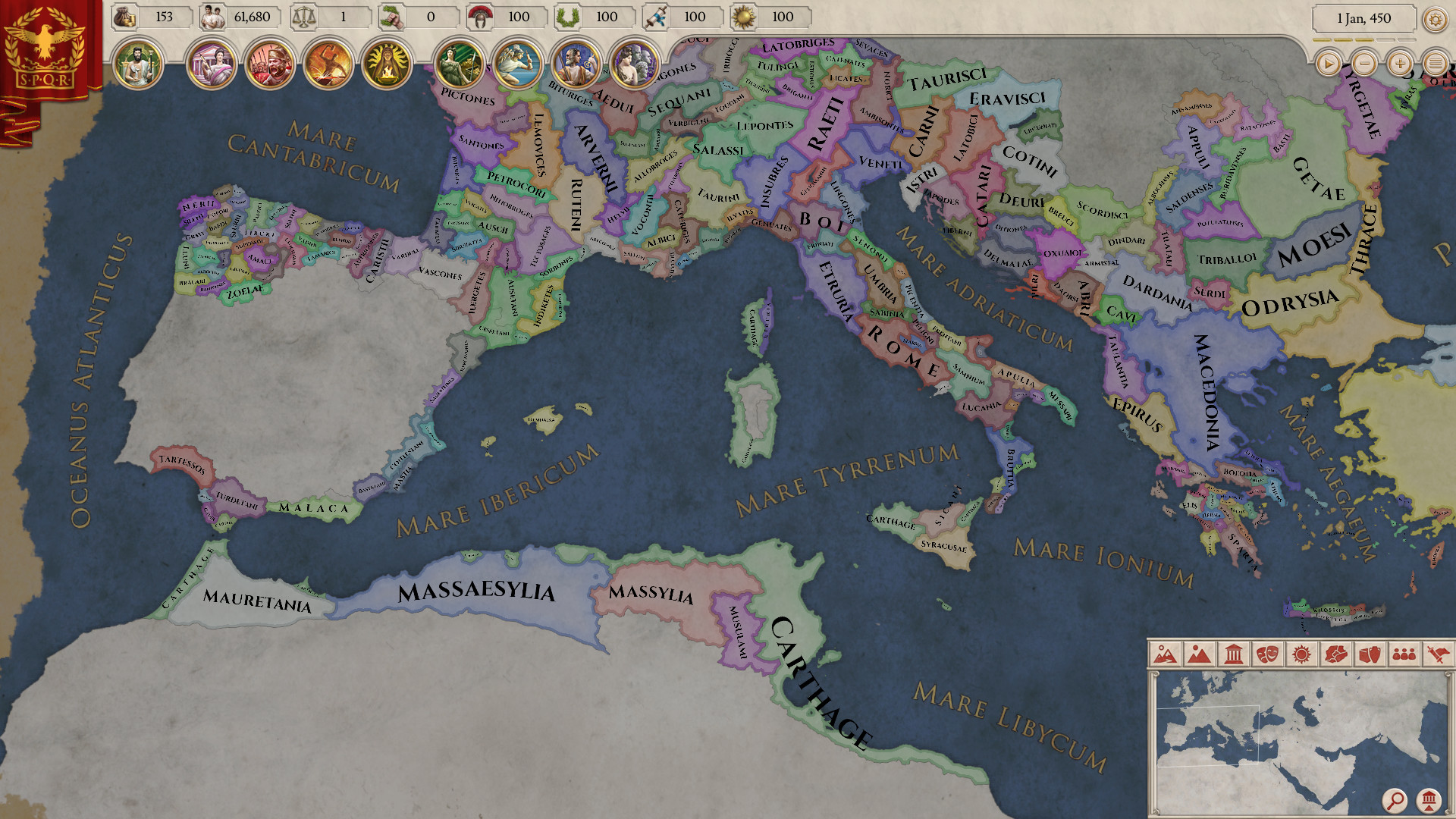
This is arguably the biggest and most detailed map we have had made for a game ever. More is not always better though, as of which the original release of HoI3 is a great example. We have taken good care into making a game where you can have interesting situations both while playing a small state, and while playing a vast empire.
In various games before, we’ve worked with organising entities on the maps in various ways, with States being groups of provinces tracing back to Vicky1. In Imperator we’ve been designing the game from the ground up with having 2 layers of interaction. The smallest part of a map is what we call a city, which corresponds to about a province in previous games. A city holds a city (or village, or metropolis), a bunch of pops, produces a trade-goods and may have a few buildings. A Province is a group of cities all belonging to the same country. A province is usually about 10 to 12 cities, and this is the entity you interact with to control trade and assign governors to.
Let us quickly compare how Sicily have been depicted in our previous games, as this is where we’ll take a look today.
- Eu2 had 2 provinces
- CK2 has 5 provinces.
- Eu4 has 3 provinces
- HoI4 has 9 provinces
In Imperator, Sicily has 23 cities (provinces in previous games), and 4 impassable mountain range areas.
This creates a much more interesting military campaign, and also more variety in your peacetime activities.
Of course, as you would expect from a game with Rome in its title, we have the entirety of Mare Nostrum covered, but there is far more of the world in the game than just that area. And with those words I’ll hand over the keys to @Arheo & @Trin Tragula , our research team!
One of the major reasons behind our choice of start date, aside from being a particularly interesting period in Roman history, is the state of the successor kingdoms in the east. We’ll go into depth about those in another development diary, however, it is worth noting that many of our decisions to include certain territories were down to their relevance within the hellenistic world, as being fascinating in their own right.
Britain made up a sizeable portion of historical Roman conquests, and played an important part in the tin trade throughout the bronze age, into the iron age. Data on pre-roman Britain is scarce, particularly for the period preceding 150 BC, and some liberties have therefore been taken regarding the extrapolation of tribal territory as known to Caesar.
The inclusion of southern Scandinavia, despite it being the epitome of all modern civilization (enough of that now - Editor), was a calculated decision. Our start date of 304 BC places us during the migration (not to be confused with the Migration Period, which occurred as of the 4th century AD) of the original Germanic tribes from modern-day Scandinavia, into northern and central Germany. The displacement of the native inhabitants (about whom very little is known), and latterly some of the celtic tribes, occurred over the course of the next several hundred years. As with Britain, very little concrete data exists on the exact nature of the locations and names of tribal groupings towards the beginning of this period.
The recorded history of the Ethiopian region extends back far further than our timeline, however, none of the contemporary sources we were able to discover, were particularly detailed regarding location data or political situation. Even now, structures built by the D’mt kingdom around 700 BC still stand, a testament to the advanced civilizations out of which the contemporaries of our start date grew. The Nile has always been the lifeblood of north-eastern africa, and we felt it was worthwhile including as much of it as possible.
The inclusion of the Indian subcontinent is something we considered as vitally necessary to complete the world that was relevant to the Hellenistic era. A state of conflict had already existed for some time between the recently established Mauryan Empire, and Seleucus Nicator, self-proclaimed King, by the time we begin. Greek traders had long-since been visiting west Indian trading ports, trading in fabrics, gemstones and spices, and indeed, many of the ancient names we have for these locations appear also in Greek, or show Greek influence.
Last of all, since we only have one start date, we have wanted to include as many interesting things as possible in it. This means that we have also tried to identify interesting states that can reasonably start as subjects of others, rather than directly owned by governors, both to better cover the political realities of far off regions like northern Anatolia or Judea, and to allow the player the choice of taking over the reins of many unique polities in these regions.
Over the course of development, we have used a great number of sources, texts and maps in order to craft what we believe, is an immersive, living world, which is as close to history as is possible. One invaluable reference tool for our Roman areas which deserves special mention, is the Digital Atlas of the Roman Empire, compiled at Lund University, using data from the Pelagios Project.
Additional sources include (but are far from limited to):
- The Schwartzberg Historical Atlas of South Asia
- An Atlas of Ancient Indian History - Habib & Habib
- Perseus Digital Library
- Pelagios Project
- Pleiades Gazetteer
It should be noted that while these have been great resources we have sometimes had to take liberties to create as full a map as possible. As such, any errors are likely to be ours and the reference materials we have used should not be faulted.

If there are any significant reference materials you believe might be relevant, we always welcome suggestions from our posters.


![Glory to Codexia! [2012] Codex 2012](/forums/smiles/campaign_tags/campaign_slushfund2012.png)


